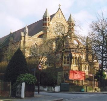
The church is situated on Leigham Court Road SW16, at the junction with Glennie Road, SE27
The post code is SW16 2SD
You can use the below Google Map to take you to the church’s location
Travel to St Peter’s
St Peter’s is on the 315 and 417 bus routes and closest Network Rail stations are Streatham Hill, West Norwood and Tulse Hill
There is parking available in local side streets
See more details below for route
See also our Accessibility page
Routes
Options are provided for BUS, TRAIN or WALKing where possible
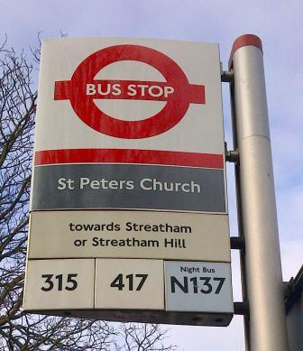
From Streatham Hill (Leigham Court Road)
BUS: 417 to St Peter’s (5 mins)
WALK: 19 mins – 1.3km (uphill)
From Central Streatham
BUS: 315 from St Leonards to St Peter’s (5 mins)
WALK: 26 mins – 1.7km (uphill)
From West Norwood
BUS: 315 From West Norwood Station (stop W towards Balham) to Leigham Court Road (St Peters) (7 mins)
.or.
BUS: 315 from York Hill SE27 towards Balham to Leigham Court Road (St Peters) (4 mins)
WALK: From West Norwood Station – 15 mins (uphill)
From Tulse Hill
BUS: Walk to York Hill SE27 (5 mins) and then 315 towards Balham to Leigham Court Road (St Peters) (4 mins)
WALK: 21 mins – 1.4km (uphill)
Trains:
Thameslink
Thameslink services run to Tulse Hill Station (see above) or Streaham Station (25 minute walk)
From Victoria Station (or Clapham Junction)
TRAIN: Trains to Streatham Hill Stn, or West Norwood Stn then see instructions above
From London Bridge Station
TRAIN: Trains to Tulse Hill Stn or West Norwood Stn, then see instructions above
From Blackfriars Stations
TRAIN: Trains to Tulse Hill Stn then see instructions above